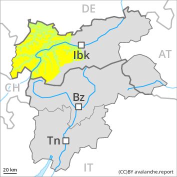
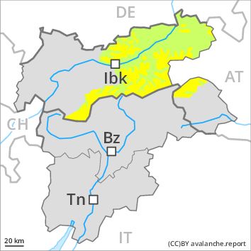
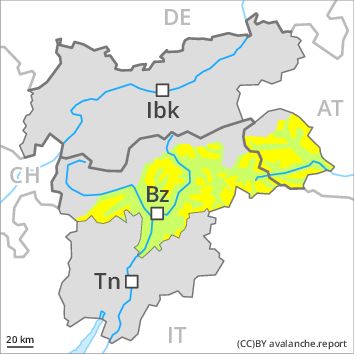
Regions
Weißkugel Range, Western Verwall Mountains, Eastern Verwall Mountains, Allgäu Alps, Silvretta, Samnaun Mountains, Eastern Lechtal Alps - Ammergau Alps, Northern Oetz and Stubai Alps, Mieming Mountains, Western Lechtal Alps, Central Lechtal Alps, Glockturm Range, Grieskogel Mountains
AM
Danger level
Danger Level 2 - Moderate above 2200m
Danger Level 1 - Low above 2200m
Avalanche Problem
Wind-drifted snow above 2200m, N-NE-E-NW
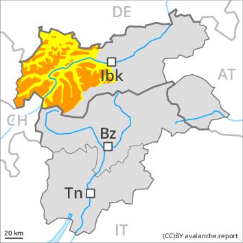
PM
Danger level
Danger Level 3 - Considerable above 2200m
Danger Level 2 - Moderate above 2200m
Avalanche Problem
Wet snow above 2000m, N-NE-E-SE-S-SW-W-NW
Wind-drifted snow above 2200m, N-NE-E-SE-NW
Gradual increase in avalanche danger as a consequence of the precipitation.
The avalanche conditions in the morning are generally favourable. Fresh wind slabs represent the main danger. In addition the no longer entirely fresh wind slabs are prone to triggering in very isolated cases still. This applies in particular on very steep shady slopes as well as adjacent to ridgelines at high altitudes and in high Alpine regions. Mostly the avalanches are only small but can be released in some cases by a single winter sport participant.
From midday as a consequence of the precipitation there will be a gradual increase in the avalanche danger. Below approximately 2000 m more frequent small and, in isolated cases, medium-sized moist avalanches are to be expected. As a consequence of fresh snow and a strong westerly wind, further wind slabs will form as well. As a consequence of warming, the likelihood of slab avalanches being released will increase a little at high altitudes and in high Alpine regions.
Snowpack
dp 6: cold, loose snow and wind
dp 3: rain
20 to 30 cm of snow, and even more in some localities, will fall. This applies above approximately 2000 m. At low and intermediate altitudes the snow is moist. This applies from the middle of the day. The sometimes strong wind will transport the fresh snow. In some places fresh snow and wind slabs are lying on soft layers, especially on shady slopes at high altitudes and in high Alpine regions. The older wind slabs have bonded quite well with the old snowpack. In very isolated cases weak layers exist in the old snowpack on shady slopes, in particular in areas where the snow cover is rather shallow.
Tendency
More frequent moist avalanches are to be expected.
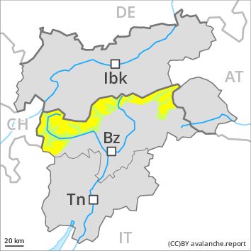
Regions
Texel Mountains, Durreck Range, Western Rieserferner Mountains, Val Müstair Alps, Langtaufers, Ortler Range, Schnals Ridge, Southern Stubai Alps, Southern Zillertal Alps and High Tauern, Saldurn-Mastaun Ridge
AM
Danger level
Danger Level 2 - Moderate above the treeline
Danger Level 1 - Low above the treeline
Avalanche Problem
Wind-drifted snow above the treeline, N-NE-E-SE-S-SW-W-NW
PM
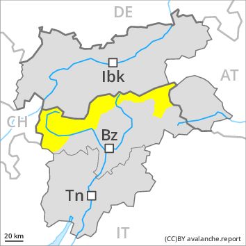
Danger level
Danger Level 2 - Moderate above the treeline
Danger Level 2 - Moderate above the treeline
Avalanche Problem
Wind-drifted snow above the treeline, N-NE-E-SE-S-SW-W-NW
Wet snow above the treeline, N-NE-E-SE-S-SW-W-NW
Fresh wind slabs require caution.
As a consequence of fresh snow and a sometimes strong wind from northerly directions, mostly small wind slabs will form as the day progresses. Caution is to be exercised in particular on very steep slopes in particular above the tree line adjacent to ridgelines. In the regions exposed to heavier precipitation the avalanche prone locations are more prevalent and larger.
As the snowfall level rises there will be an increase in the danger of moist and wet avalanches. Small and medium-sized natural wet avalanches are possible as a consequence of the rain.
Snowpack
dp 6: cold, loose snow and wind
5 to 10 cm of snow, and even more in some localities, will fall. The sometimes strong wind will transport the fresh snow. In some places fresh snow and wind slabs are lying on soft layers, especially on shady slopes above approximately 2200 m. The older wind slabs have bonded well with the old snowpack.
Tendency
As a consequence of warming, the likelihood of moist and wet avalanches being released will increase for a while.
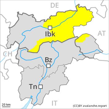
Regions
Western Tuxer Alps, Karwendel Mountains, Eastern Tuxer Alps, Brandenberg Alps, Western Kitzbühel Alps, Wilder Kaiser Mountains - Waidring Alps, Eastern Kitzbühel Alps, Gurgler Range, Central Stubai Alps, Northern Zillertal Alps, Venediger Range
AM
Danger level
Danger Level 2 - Moderate above 2200m
Danger Level 1 - Low above 2200m
Avalanche Problem
Wind-drifted snow above 2200m, N-NE-E-NW
PM
Danger level
Danger Level 2 - Moderate above 2200m
Danger Level 2 - Moderate above 2200m
Avalanche Problem
Wet snow above 2000m, N-NE-E-SE-S-SW-W-NW
Wind-drifted snow above 2200m, N-NE-E-SE-NW
Gradual increase in avalanche danger as a consequence of the precipitation.
The avalanche conditions in the morning are generally favourable. Fresh wind slabs represent the main danger. In addition the no longer entirely fresh wind slabs are prone to triggering in very isolated cases still. This applies in particular on very steep shady slopes as well as adjacent to ridgelines at high altitudes and in high Alpine regions. Mostly the avalanches are only small but can be released in some cases by a single winter sport participant.
From midday as a consequence of the precipitation there will be a gradual increase in the avalanche danger. Below approximately 2000 m more frequent small and, in isolated cases, medium-sized moist avalanches are to be expected. As a consequence of fresh snow and a strong westerly wind, further wind slabs will form as well. As a consequence of warming, the likelihood of slab avalanches being released will increase a little at high altitudes and in high Alpine regions.
Snowpack
dp 6: cold, loose snow and wind
dp 3: rain
10 to 20 cm of snow. will fall. This applies above approximately 2000 m. At low and intermediate altitudes the snow is moist. This applies from the middle of the day. The sometimes strong wind will transport the fresh snow. In some places fresh snow and wind slabs are lying on soft layers, especially on shady slopes at high altitudes and in high Alpine regions. The older wind slabs have bonded quite well with the old snowpack. In very isolated cases weak layers exist in the old snowpack on shady slopes, in particular in areas where the snow cover is rather shallow.
Tendency
More frequent moist avalanches are to be expected.
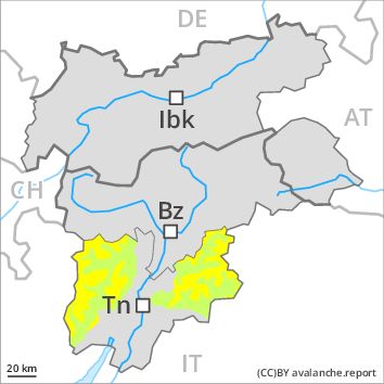
Regions
Prealps, Cembra Valley, Bondone and Stivo, Vallarsa, Western Nonsberg Alps, Folgaria - Laverone, Ledro Valley, Paganella, Marzola - Valsugana
Danger level
Danger Level 2 - Moderate above the treeline
Danger Level 1 - Low above the treeline
Avalanche Problem
Wind-drifted snow above the treeline, N-NE-E-SE-S-SW-W-NW

Wind slabs require caution.
In some regions light snowfall to above 1200 m. As a consequence of a sometimes strong wind from northwesterly directions, wind slabs formed on Saturday. These must be evaluated with care and prudence in all aspects. The avalanche prone locations are to be found in particular on very steep shady slopes above approximately 2000 m and adjacent to ridgelines. In some cases the avalanches are medium-sized. At high altitudes and in high Alpine regions the avalanche prone locations are more prevalent and larger.
Snowpack
dp 6: cold, loose snow and wind
Little snow will fall in some localities. In some places fresh snow and wind slabs are lying on old snow containing large grains. This applies in particular on shady slopes at high altitudes and in high Alpine regions. The old snowpack will be subject to considerable local variations at low and intermediate altitudes. At low altitude no snow is lying on south facing slopes.
Tendency
Gradual increase in avalanche danger as a consequence of warming during the day and solar radiation.
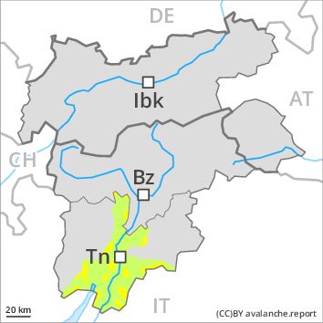
Regions
Southern Adamello, Primiero - Pale di S. Martino, Adamello - Presanella, Northern Brenta - Peller, Southern Brenta, Fassa Valley, Southern Lagorai, Sole, Pejo and Rabbi, Northern Lagorai, Latemar, Maddalene, Pine' - Mocheni Valley
Danger level
Danger Level 2 - Moderate above 2400m
Danger Level 1 - Low above 2400m
Avalanche Problem
Wind-drifted snow above 2400m, N-NE-E-SE-S-SW-W-NW
Wind slabs require caution, especially above approximately 2400 m adjacent to ridgelines.
In some regions light snowfall to above 1200 m. As a consequence of a sometimes strong wind from northwesterly directions, wind slabs formed on Saturday. Caution is to be exercised in particular on very steep slopes above approximately 2400 m adjacent to ridgelines. These avalanche prone locations are rather rare and are clearly recognisable to the trained eye. In the regions exposed to heavier precipitation the avalanche prone locations are more prevalent and larger.
Snowpack
dp 6: cold, loose snow and wind
0 to 10 cm of snow. will fall. In some places wind slabs are lying on soft layers, especially on shady slopes above approximately 2400 m. The older wind slabs have bonded well with the old snowpack. In very isolated cases weak layers exist in the old snowpack on shady slopes, in particular in areas where the snow cover is rather shallow. At low altitude a little snow is lying.
Tendency
The avalanche danger will persist.
Regions
Sexten Dolomites, Eastern Pfunderer Mountains, Western Deferegger Alps, Ulten Valley, Eastern Nonsberger Alps, Eastern Rieserferner Mountains, Northern Dolomites of Fiemme, Glockner Range, Gröden Dolomites, Eastern Deferegger Alps, Prags Dolomites, Sarntal Alps, Schober Mountains, Western Pfunderer Mountains, Lienzer Dolomites
Danger level
Danger Level 2 - Moderate above 2200m
Danger Level 1 - Low above 2200m
Avalanche Problem
Wind-drifted snow above 2200m, N-NE-E-SE-S-NW
Fresh wind slabs require caution, especially above approximately 2200 m adjacent to ridgelines.
As a consequence of fresh snow and a sometimes strong wind from northerly directions, mostly small wind slabs will form. Caution is to be exercised in particular on very steep slopes above approximately 2200 m adjacent to ridgelines. These avalanche prone locations are rather rare and are clearly recognisable to the trained eye. As the day progresses as a consequence of warming there will be a gradual increase in the danger of moist and wet avalanches.
Snowpack
dp 6: cold, loose snow and wind
In some localities up to 5 cm of snow. will fall. The sometimes strong wind will transport the fresh snow. In some places fresh snow and wind slabs are lying on soft layers, especially on shady slopes above approximately 2200 m. The older wind slabs have bonded well with the old snowpack. In very isolated cases weak layers exist in the old snowpack on shady slopes, in particular in areas where the snow cover is rather shallow.
Tendency
As a consequence of warming, the likelihood of moist and wet avalanches being released will increase for a while.