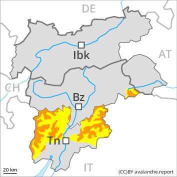
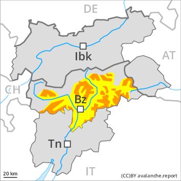
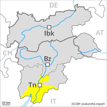
Regions
Texel Mountains, Durreck Range, Western Rieserferner Mountains, Val Müstair Alps, Langtaufers, Ortler Range, Schnals Ridge, Southern Stubai Alps, Southern Zillertal Alps and High Tauern
AM
Danger level
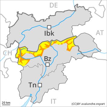
Danger Level 2 - Moderate above 2400m
Danger Level 3 - Considerable above 2400m
Avalanche Problem
Wet snow above 2400m, N-NE-E-SE-S-SW-W-NW
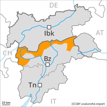
Wind-drifted snow above 2400m, N-NE-E-NW
PM
Danger level
Danger Level 3 - Considerable above 2400m
Danger Level 3 - Considerable above 2400m
Avalanche Problem
Wet snow, N-NE-E-SE-S-SW-W-NW
Further increase in danger of wet and gliding avalanches as a consequence of warming.
In all aspects and below approximately 2400 m moist and wet avalanches are possible at any time, even quite large ones. Transportation routes situated at higher altitudes in particular can be endangered occasionally. Gradual increase in danger of wet and gliding avalanches as a consequence of warming during the day and solar radiation. This applies in particular in case of releases originating from starting zones above approximately 2400 m that have retained the snow thus far. The mostly small wind slabs can be released, especially by large additional loads, in particular on northwest to north to east facing aspects above approximately 2400 m.
Snowpack
Outgoing longwave radiation during the night will be quite good over a wide area. The surface of the snowpack has frozen to form a strong crust only at high altitudes and will soften quickly. The more recent wind slabs are clearly recognisable to the trained eye. Backcountry touring calls for caution and restraint. The snowpack will be wet all the way through below approximately 2000 m.
Tendency
As the temperature drops the natural avalanche activity will gradually decrease.
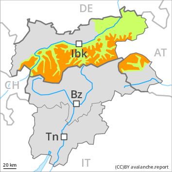
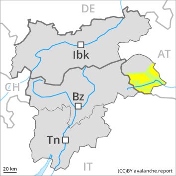
Regions
Karwendel Mountains, Western Lechtal Alps, Central Lechtal Alps, Western Verwall Mountains, Eastern Verwall Mountains, Silvretta, Allgäu Alps, Eastern Lechtal Alps - Ammergau Alps, Mieming Mountains
AM

Danger level
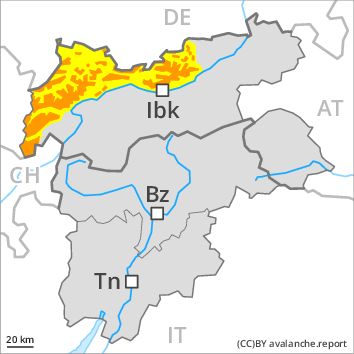
Danger Level 3 - Considerable above 2300m
Danger Level 2 - Moderate above 2300m
Avalanche Problem
Wind-drifted snow above 2300m, N-NE-E-SE-NW
Gliding snow above 2300m, N-NE-E-SE-S-SW-W-NW
PM
Danger level
Danger Level 3 - Considerable above 2300m
Danger Level 2 - Moderate above 2300m
Avalanche Problem
Wet snow, E-SE-S-SW-W
Gliding snow above 2300m, N-NE-E-SE-S-SW-W-NW
Increase in danger of moist avalanches as a consequence of warming during the day and solar radiation. The avalanche conditions in the morning below approximately 2300 m are generally favourable.
Numerous moist avalanches have been released as a consequence of the precipitation. In all regions there will be an appreciable decrease in the avalanche danger during the course of the night.
Late morning: Fresh and older wind slabs represent the main danger. These can be released by a single winter sport participant in particular on northwest to north to southeast facing aspects at high altitudes and in high Alpine regions. The prevalence of avalanche prone locations and likelihood of triggering will increase with altitude. In addition a moderate (level 2) danger of gliding avalanches exists, especially below approximately 2300 m on steep grassy slopes.
Midday and afternoon: As the day progresses as a consequence of warming during the day and solar radiation there will be a rapid increase in the danger of moist and wet avalanches. More frequent small and medium-sized moist loose snow avalanches are to be expected. This applies on extremely steep sunny slopes. More frequent small and medium-sized gliding avalanches are to be expected. This applies on steep grassy slopes in all aspects below approximately 2300 m. This also applies on steep sunny slopes below approximately 2600 m. As the day progresses the likelihood of slab avalanches being released will increase a little at high altitudes and in high Alpine regions.
Snowpack
dp 10: springtime scenario
dp 6: cold, loose snow and wind
Outgoing longwave radiation during the night will be good over a wide area. The surface of the snowpack will freeze to form a strong crust only at high altitudes and will soften during the day. The old snowpack will be wet all the way through at low and intermediate altitudes. In some places fresh snow and wind slabs are lying on soft layers. This applies in particular above approximately 2300 m. In very isolated cases weak layers exist in the old snowpack in particular on west, north and northeast facing slopes, especially above approximately 2500 m.
Tendency
Decrease in avalanche danger as the temperature drops.
Regions
Sexten Dolomites, Latemar, Southern Adamello, Primiero - Pale di S. Martino, Adamello - Presanella, Northern Brenta - Peller, Western Nonsberg Alps, Southern Brenta, Fassa Valley, Sole, Pejo and Rabbi, Southern Lagorai, Northern Lagorai, Maddalene, Paganella, Pine' - Mocheni Valley
AM
Danger level
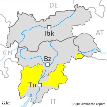
Danger Level 2 - Moderate above the treeline
Danger Level 2 - Moderate above the treeline
Avalanche Problem
Wet snow, N-NE-E-SE-S-SW-W-NW
Persistent weak layer above 2200m, N-NE-NW
PM
Danger level
Danger Level 3 - Considerable above the treeline
Danger Level 2 - Moderate above the treeline
Avalanche Problem
Wet snow, N-NE-E-SE-S-SW-W-NW
Persistent weak layer above 2200m, N-NE-NW
The danger of moist and wet avalanches will increase during the day.
Especially on rocky sunny slopes and on wind-loaded slopes numerous medium-sized and, in isolated cases, large natural wet avalanches are possible as a consequence of warming. The danger of wet and gliding avalanches will increase during the day. Weak layers exist in the snowpack in particular on wind-loaded slopes. This applies on steep northeast, north and northwest facing slopes above approximately 2200 m adjacent to ridgelines. These avalanche prone locations are difficult to recognise. The sometimes fresh snow-covered wind slabs are to be evaluated with care and prudence in particular in very steep terrain. In the regions exposed to heavier precipitation the avalanche prone locations are more prevalent and larger. As a consequence of warming, the likelihood of moist and wet avalanches being released will increase gradually in particular on steep slopes at intermediate altitudes.
Snowpack
dp 10: springtime scenario
The older wind slabs have bonded well with the old snowpack. In very isolated cases weak layers exist in the old snowpack on shady slopes, in particular in areas where the snow cover is rather shallow. In some places wind slabs are lying on soft layers, in particular on shady slopes above approximately 2400 m. At low altitude a little snow is lying.
Tendency
Slight decrease in avalanche danger as the snowfall level drops.
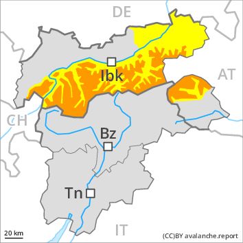
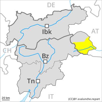
Regions
Weißkugel Range, Gurgler Range, Central Stubai Alps, Northern Zillertal Alps, Venediger Range, Samnaun Mountains, Northern Oetz and Stubai Alps, Eastern Rieserferner Mountains, Western Tuxer Alps, Glockner Range, Eastern Tuxer Alps, Brandenberg Alps, Western Kitzbühel Alps, Wilder Kaiser Mountains - Waidring Alps, Eastern Kitzbühel Alps, Glockturm Range, Grieskogel Mountains
AM
Danger level
Danger Level 3 - Considerable above 2300m
Danger Level 1 - Low above 2300m
Avalanche Problem
Wind-drifted snow above 2300m, N-NE-E-SE-NW
Gliding snow above 2300m, N-NE-E-SE-S-SW-W-NW
PM
Danger level
Danger Level 3 - Considerable above 2300m
Danger Level 2 - Moderate above 2300m
Avalanche Problem
Wet snow, E-SE-S-SW-W
Gliding snow above 2300m, N-NE-E-SE-S-SW-W-NW
Increase in danger of moist avalanches as a consequence of warming during the day and solar radiation. The avalanche conditions in the morning below approximately 2300 m are generally favourable.
Numerous moist avalanches have been released as a consequence of the precipitation. In all regions there will be an appreciable decrease in the avalanche danger during the course of the night.
Late morning: Fresh and older wind slabs represent the main danger. These can be released by a single winter sport participant in particular on northwest to north to southeast facing aspects at high altitudes and in high Alpine regions. The prevalence of avalanche prone locations and likelihood of triggering will increase with altitude. In addition a certain danger of gliding avalanches exists, especially below approximately 2300 m on steep grassy slopes.
Midday and afternoon: As the day progresses as a consequence of warming during the day and solar radiation there will be a rapid increase in the danger of moist and wet avalanches. More frequent small and medium-sized moist loose snow avalanches are to be expected. This applies on extremely steep sunny slopes. More frequent small and medium-sized gliding avalanches are to be expected. This applies on steep grassy slopes in all aspects below approximately 2300 m. This also applies on steep sunny slopes below approximately 2600 m. As the day progresses the likelihood of slab avalanches being released will increase a little at high altitudes and in high Alpine regions.
Snowpack
dp 10: springtime scenario
dp 6: cold, loose snow and wind
Outgoing longwave radiation during the night will be good over a wide area. The surface of the snowpack will freeze to form a strong crust only at high altitudes and will soften during the day. The old snowpack will be wet all the way through at low and intermediate altitudes. In some places fresh snow and wind slabs are lying on soft layers. This applies in particular above approximately 2300 m. In very isolated cases weak layers exist in the old snowpack in particular on west, north and northeast facing slopes, especially above approximately 2500 m.
Tendency
Decrease in avalanche danger as the temperature drops.
Regions
Gröden Dolomites, Prags Dolomites, Sarntal Alps, Western Pfunderer Mountains, Eastern Pfunderer Mountains, Western Deferegger Alps, Ulten Valley, Eastern Nonsberger Alps, Northern Dolomites of Fiemme, Saldurn-Mastaun Ridge
AM
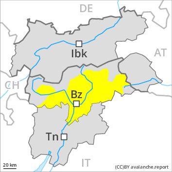
Danger level
Danger Level 2 - Moderate above 1800m
Danger Level 2 - Moderate above 1800m
Avalanche Problem
Wet snow above 2400m, N-NE-E-SE-S-SW-W-NW
Persistent weak layer above 2400m, N-NE-NW
PM
Danger level
Danger Level 3 - Considerable above 1800m
Danger Level 2 - Moderate above 1800m
Avalanche Problem
Wet snow, N-NE-E-SE-S-SW-W-NW
Persistent weak layer above 2400m, N-NE-NW
The danger of moist and wet avalanches will already increase in the early morning.
More frequent medium-sized and, in isolated cases, large moist and wet avalanches are possible in all altitude zones. The danger of wet and gliding avalanches will increase quickly during the day. Weak layers exist in the snowpack. This applies on steep northeast, north and northwest facing slopes above approximately 2400 m. These avalanche prone locations are difficult to recognise. Weak layers in the old snowpack can be released in isolated cases even by individual winter sport participants in particular on steep, little used shady slopes.
Snowpack
Outgoing longwave radiation during the night will be quite good over a wide area. The surface of the snowpack will freeze to form a strong crust only at high altitudes and will soften earlier than the day before. Faceted weak layers exist in the old snowpack on shady slopes, in particular in areas where the snow cover is rather shallow. The older wind slabs have bonded well with the old snowpack.
Tendency
Gradual decrease in danger of wet avalanches as the temperature drops.
Regions
Eastern Deferegger Alps, Schober Mountains, Lienzer Dolomites
AM
Danger level
Danger Level 2 - Moderate above 2300m
Danger Level 1 - Low above 2300m
Avalanche Problem
Wind-drifted snow above 2300m, N-NE-E-SE-NW
PM
Danger level
Danger Level 2 - Moderate above 2300m
Danger Level 2 - Moderate above 2300m
Avalanche Problem
Wet snow, E-SE-S-SW-W
Gliding snow above 2300m, N-NE-E-SE-S-SW-W-NW
Increase in danger of moist avalanches as a consequence of warming during the day and solar radiation. The avalanche conditions in the morning below approximately 2300 m are generally favourable.
Early morning: Fresh and older wind slabs represent the main danger. These can be released in isolated cases, but mostly only by large additional loads, in particular on northwest to north to southeast facing aspects above approximately 2300 m. The prevalence of avalanche prone locations and likelihood of triggering will increase with altitude.
Midday and afternoon: As the day progresses as a consequence of warming during the day and solar radiation there will be a rapid increase in the danger of moist and wet avalanches. More frequent small and medium-sized moist loose snow avalanches are to be expected. This applies on extremely steep sunny slopes. More frequent small and medium-sized gliding avalanches are to be expected. This applies on steep grassy slopes in all aspects below approximately 2200 m. This also applies on steep sunny slopes below approximately 2600 m. As the day progresses the likelihood of slab avalanches being released will increase a little at high altitudes and in high Alpine regions.
Snowpack
dp 10: springtime scenario
dp 6: cold, loose snow and wind
Outgoing longwave radiation during the night will be good over a wide area. The surface of the snowpack will freeze to form a strong crust and will soften during the day. The old snowpack will be moist at low and intermediate altitudes. In some places fresh snow and wind slabs are lying on soft layers. This applies in particular above approximately 2300 m. In very isolated cases weak layers exist in the old snowpack in particular on shady slopes.
Tendency
Decrease in avalanche danger as the temperature drops.
Regions
Prealps, Cembra Valley, Bondone and Stivo, Vallarsa, Folgaria - Laverone, Ledro Valley, Marzola - Valsugana
AM
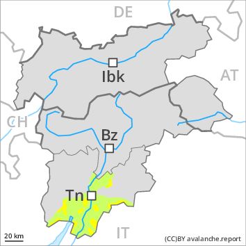
Danger level
Danger Level 2 - Moderate above the treeline
Danger Level 1 - Low above the treeline
Avalanche Problem
Wet snow above the treeline, N-NE-E-SE-S-SW-W-NW
PM
Danger level
Danger Level 2 - Moderate above the treeline
Danger Level 2 - Moderate above the treeline
Avalanche Problem
Wet snow above the treeline, N-NE-E-SE-S-SW-W-NW
Gliding snow above the treeline, N-NE-E-SE-S-SW-W-NW
As a consequence of warming and solar radiation an unfavourable avalanche situation will be encountered in some regions.
The surface of the snowpack will freeze to form a strong crust only at high altitudes and will soften quickly. The danger of wet and gliding avalanches will increase but remain within the current danger level. As a consequence of warming during the day and the solar radiation, the likelihood of moist and wet avalanches being released will increase gradually in particular on rocky slopes at intermediate and high altitudes. In particular on steep sunny slopes and on wind-loaded slopes more frequent small to medium-sized moist avalanches are possible until the temperature drops.
Snowpack
dp 2: gliding snow
In some places fresh snow and wind slabs are lying on old snow containing large grains. This applies in particular on shady slopes at high altitudes and in high Alpine regions. The old snowpack will be subject to considerable local variations at low and intermediate altitudes. At low altitude no snow is lying on south facing slopes.
Tendency
Slight decrease in avalanche danger as the snowfall level drops.