Regions
Sexten Dolomites, Val Müstair Alps, Western Verwall Mountains, Langtaufers, Eastern Verwall Mountains, Schnals Ridge, Silvretta, Southern Stubai Alps, Samnaun Mountains, Southern Zillertal Alps and High Tauern, Northern Oetz and Stubai Alps, Saldurn-Mastaun Ridge, Western Tuxer Alps, Texel Mountains, Eastern Tuxer Alps, Sarntal Alps, Western Kitzbühel Alps, Western Pfunderer Mountains, Eastern Kitzbühel Alps, Glockturm Range, Eastern Pfunderer Mountains, Durreck Range, Weißkugel Range, Western Rieserferner Mountains, Gurgler Range, Western Deferegger Alps, Central Stubai Alps, Ortler Range, Allgäu Alps, Northern Zillertal Alps, Ulten Valley, Eastern Lechtal Alps - Ammergau Alps, Venediger Range, Mieming Mountains, Eastern Rieserferner Mountains, Karwendel Mountains, Glockner Range, Gröden Dolomites, Brandenberg Alps, Eastern Deferegger Alps, Prags Dolomites, Wilder Kaiser Mountains - Waidring Alps, Schober Mountains, Western Lechtal Alps, Lienzer Dolomites, Central Lechtal Alps, Grieskogel Mountains
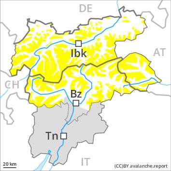
Danger level
Danger Level 2 - Moderate above 2000m
No Rating above 2000m
Avalanche Problem
Wet snow above 2000m, E-SE-S-SW
Wind-drifted snow above 2800m, N-NE-E-SE-S-SW-W-NW

The danger of loose snow avalanches will increase quickly in the early morning, in the regions exposed to a lot of fresh snow especially.
The Avalanche Warning Service currently has only a small amount of information that has been collected in the field.
Above approximately 2000 m snow has fallen over a wide area. As a consequence of warming during the day and the solar radiation, the likelihood of loose snow avalanches being released will increase quickly in particular on steep sunny slopes. Natural avalanches are likely to occur. In some cases the avalanches are medium-sized.
The wind will be moderate to strong at times. Adjacent to ridgelines and in gullies and bowls further wind slabs will form. As a consequence of warming during the day, the likelihood of slab avalanches being released will increase a little in particular on steep shady slopes above approximately 2800 m. Avalanches are rather small but can be released in isolated cases by a single winter sport participant. The number and size of avalanche prone locations will increase with altitude.
Snowpack
dp 10: springtime scenario
dp 6: cold, loose snow and wind
In some regions 10 to 20 cm of snow, and even more in some localities, fell above approximately 2000 m. The snowpack will become moist in particular on sunny slopes. Individual weak layers exist in the old snowpack on steep shady slopes, especially above approximately 2800 m. At low altitude no snow is lying.
Tendency
Slight increase in avalanche danger as a consequence of fresh snow and wind.
Regions
Southern Adamello, Primiero - Pale di S. Martino, Adamello - Presanella, Northern Brenta - Peller, Southern Brenta, Fassa Valley, Sole, Pejo and Rabbi, Southern Lagorai, Northern Lagorai, Latemar, Maddalene
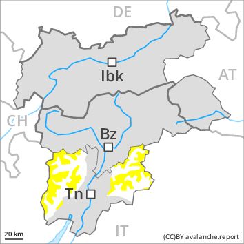
Danger level
Danger Level 2 - Moderate above 2000m
No Rating above 2000m
Avalanche Problem
Wind-drifted snow above 2400m, N-NE-E-SE-S-SW-W-NW
Wet snow above 2000m, NE-E-SE-S-SW
The danger of loose snow avalanches will increase quickly in the early morning, in the regions exposed to a lot of fresh snow especially.
The Avalanche Warning Service currently has only a small amount of information that has been collected in the field.
Above approximately 2000 m snow has fallen over a wide area. The wind will be light to moderate over a wide area. Adjacent to ridgelines and in gullies and bowls further wind slabs will form. Avalanches are rather small but can be released in isolated cases by a single winter sport participant. As the day progresses the likelihood of avalanches being released will increase a little. The number and size of avalanche prone locations will increase with altitude.
Snowpack
dp 10: springtime scenario
dp 6: cold, loose snow and wind
In some regions 10 to 20 cm of snow, and even more in some localities, fell above approximately 2200 m. Individual weak layers exist deep in the old snowpack on steep shady slopes, especially above approximately 2800 m in areas where the snow cover is rather shallow. At low altitude no snow is lying.
Tendency
Slight increase in danger of dry and moist avalanches as the snowfall level drops. As the snowfall becomes more intense the avalanche prone locations will become more prevalent on Thursday.
Regions
Prealps, Cembra Valley, Bondone and Stivo, Vallarsa, Folgaria - Laverone, Western Nonsberg Alps, Ledro Valley, Eastern Nonsberger Alps, Paganella, Northern Dolomites of Fiemme, Pine' - Mocheni Valley, Marzola - Valsugana
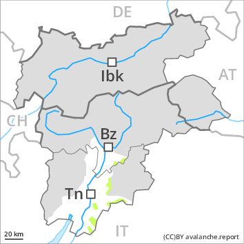
Danger level
Danger Level 1 - Low above 2000m
No Rating above 2000m
Avalanche Problem
Wet snow above 2400m above 2000m, N-NE-E-SE-S-SW-W-NW
Wind-drifted snow above 2100m, N-NE-E-SE-S-SW-W-NW
Slight decrease in danger of moist and wet avalanches as the temperature drops.
The Avalanche Warning Service currently has only a small amount of information that has been collected in the field.
Over a wide area rain below approximately 2400 m. The snowpack remains in most cases moist. Moist and wet avalanches require caution. In some regions some fresh snow above approximately 2100 m. As a consequence of fresh snow and wind individual slab avalanches are possible, but they will be mostly small.
Snowpack
dp 3: rain
dp 6: cold, loose snow and wind
Outgoing longwave radiation during the night will be good in some case. The surface of the snowpack will freeze, but a strong crust will not form and will soften quickly. In some regions some fresh snow above approximately 2100 m. The fresh snow is bonding quite well with the old snowpack below approximately 2400 m. At low altitude no snow is lying.
Tendency
Slight decrease in danger of moist and wet avalanches as the snowfall level drops. The fresh snow must be evaluated with care and prudence above approximately 2000 m. As the snowfall becomes more intense the avalanche prone locations will become more prevalent on Thursday.