Regions
Texel Mountains, Gröden Dolomites, Prags Dolomites, Sexten Dolomites, Ortler Range, Schnals Ridge, Southern Stubai Alps, Ulten Valley, Saldurn-Mastaun Ridge
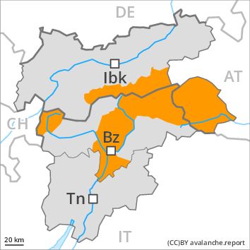
Danger level
Danger Level 4 - High
Avalanche Problem
Gliding snow above 2500m, N-NE-E-SE-S-SW-W-NW
Wind-drifted snow above 2200m, N-NE-E-W-NW

Gliding snow represents the main danger. Fresh wind slabs require caution, in particular above approximately 2200 m.
On steep grassy slopes more gliding avalanches are possible, even quite large ones, in the regions exposed to heavier precipitation especially, in particular in the east. In addition the deep wind slabs of the last few days above approximately 2200 m are prone to triggering now as before. Avalanches can be released, even by a single winter sport participant and reach large size in isolated cases. The prevalence of avalanche prone locations and likelihood of triggering will increase with altitude. As a consequence of the sometimes strong southerly wind more natural avalanches are possible, even very large ones in isolated cases, in particular in shady places that are protected from the wind at high altitudes and in high Alpine regions. Snow sport activities outside marked and open pistes call for very extensive experience in the assessment of avalanche danger and great restraint.
Snowpack
dp 2: gliding snow
dp 6: cold, loose snow and wind
In particular in the Dolomites, in the Ortler Range and in the Passeier Tal 20 to 30 cm of snow, and even more in some localities, will fall. The wind will be strong adjacent to ridgelines. In some places wind slabs are lying on soft layers, especially at elevated altitudes. The fresh wind slabs are in many cases thick and can in some cases be released easily especially at their margins. The snowpack will be moist at low and intermediate altitudes.
Tendency
The avalanche danger will persist.
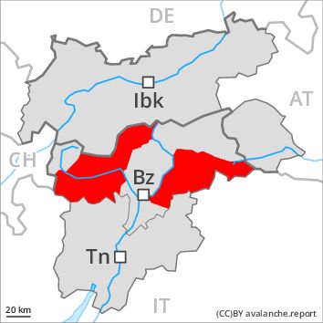
Regions
Primiero - Pale di S. Martino, Adamello - Presanella, Northern Brenta - Peller, Fassa Valley, Sole, Pejo and Rabbi, Northern Lagorai, Latemar, Maddalene
Danger level
Danger Level 4 - High
Avalanche Problem
Gliding snow above 2400m, E-SE-S-SW-W
Wind-drifted snow above the treeline, N-NE-E-SE-S-SW-W-NW
Fresh snow represents the main danger. Fresh wind slabs are to be evaluated with care and prudence, especially above approximately 2000 m.
Numerous natural avalanches have been released as a consequence of fresh snow and strong wind.
On steep grassy slopes more gliding avalanches are possible, even quite large ones, in the regions exposed to heavier precipitation especially.
In addition the wind slabs of the last few days above approximately 2000 m are prone to triggering. Avalanches can be released by small loads and reach large size in isolated cases. The prevalence of avalanche prone locations and likelihood of triggering will increase with altitude.
Snow sport activities outside marked and open pistes call for extensive experience in the assessment of avalanche danger.
Snowpack
dp 2: gliding snow
dp 6: cold, loose snow and wind
80 to 120 cm of snow, and even more in some localities, has fallen in the last few days. The wind was moderate to strong adjacent to ridgelines. In some places wind slabs are lying on soft layers, especially at elevated altitudes. The fresh wind slabs are in many cases very large and can be released easily. The snowpack will be moist at low and intermediate altitudes. 30 to 50 cm of snow, and even more in some localities, will fall in the next few hours above approximately 1200 m.
Tendency
The avalanche danger will decrease gradually.
Regions
Western Tuxer Alps, Eastern Tuxer Alps, Glockturm Range, Weißkugel Range, Gurgler Range, Northern Oetz and Stubai Alps
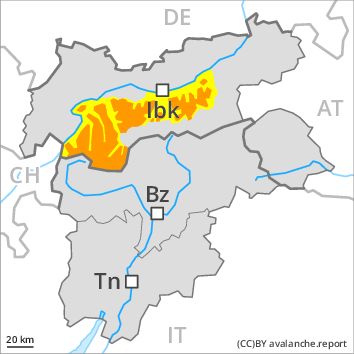
Danger level
Danger Level 3 - Considerable above 2200m
Danger Level 2 - Moderate above 2200m
Avalanche Problem
Wind-drifted snow above 2200m, N-NE-E-W-NW
Gliding snow above 2600m, N-NE-E-SE-S-SW-W-NW
Fresh wind slabs above approximately 2200 m. Below approximately 2600 m gliding avalanches and snow slides are possible.
The fresh wind slabs represent the main danger. These are sometimes thick. They can be released by a single winter sport participant in some cases especially on very steep shady slopes above approximately 2200 m, especially at transitions from a shallow to a deep snowpack, when entering gullies and bowls for example.
On steep grassy slopes more gliding avalanches and snow slides are possible, in the regions exposed to heavier precipitation especially.
Snowpack
dp 6: cold, loose snow and wind
dp 2: gliding snow
As a consequence of a strong to storm force southerly wind, wind slabs formed in the last few days at elevated altitudes. In some places wind slabs are lying on soft layers, in particular above approximately 2200 m. The snowpack will be wet all the way through at low and intermediate altitudes.
Tendency
Further decrease in avalanche danger.
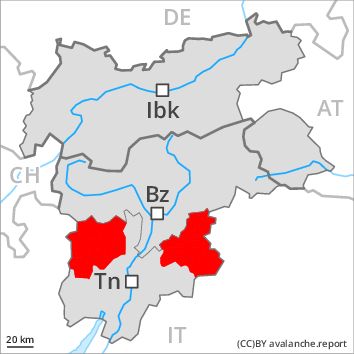
Regions
Southern Adamello, Prealps, Cembra Valley, Bondone and Stivo, Vallarsa, Western Nonsberg Alps, Folgaria - Laverone, Southern Brenta, Southern Lagorai, Ledro Valley, Paganella, Marzola - Valsugana, Pine' - Mocheni Valley
Danger level
Danger Level 3 - Considerable
Avalanche Problem
New snow above the treeline, N-NE-E-SE-S-SW-W-NW
Gliding snow above the treeline, N-NE-E-SE-S-SW-W-NW
An unfavourable avalanche situation will still be encountered. More medium-sized and, in isolated cases, large moist loose snow avalanches are possible.
The avalanches can over a wide area be released by small loads or triggered naturally. In particular on steep grassy slopes more medium-sized and, in isolated cases, large gliding avalanches are to be expected. The prevalence of avalanche prone locations and likelihood of triggering will increase with altitude.
Snowpack
dp 3: rain
dp 2: gliding snow
40 to 80 cm of snow, and even more in some localities, has fallen in the last few days. 20 to 40 cm of snow. will fall in the next few hours above approximately 1500 m.
The snowpack remains generally prone to triggering. Over a wide area fresh snow and wind slabs are lying on soft layers, especially above the tree line. Dry avalanches can release deeper layers of the snowpack reach large size.
The snowpack remains moist at low and intermediate altitudes.
Tendency
The avalanche danger will decrease gradually.
Regions
Eastern Pfunderer Mountains, Durreck Range, Western Rieserferner Mountains, Val Müstair Alps, Western Deferegger Alps, Langtaufers, Central Stubai Alps, Northern Zillertal Alps, Venediger Range, Southern Zillertal Alps and High Tauern, Eastern Nonsberger Alps, Eastern Rieserferner Mountains, Northern Dolomites of Fiemme, Glockner Range, Eastern Deferegger Alps, Sarntal Alps, Schober Mountains, Western Pfunderer Mountains, Lienzer Dolomites
Danger level
Danger Level 3 - Considerable
Avalanche Problem
Gliding snow above 2600m, N-NE-E-SE-S-SW-W-NW
Wind-drifted snow above 2200m, N-NE-E-W-NW
Gliding snow represents the main danger. This applies on steep grassy slopes. Fresh wind slabs require caution, in particular above approximately 2200 m.
On steep grassy slopes more gliding avalanches are possible, even quite large ones, in the regions exposed to heavier precipitation especially, in particular in the east. This applies below approximately 2600 m.
The fresh wind slabs are in some cases still prone to triggering above approximately 2200 m, especially on very steep shady slopes and adjacent to ridgelines. The prevalence of avalanche prone locations and likelihood of triggering will increase with altitude. Large avalanches are possible in isolated cases.
Snow sport activities outside marked and open pistes call for experience in the assessment of avalanche danger.
Snowpack
dp 2: gliding snow
dp 6: cold, loose snow and wind
The snowpack will be wet all the way through at low and intermediate altitudes. In some places wind slabs are lying on soft layers, especially at high altitudes and in high Alpine regions. The sometimes strong wind will transport the fresh snow. The fresh wind slabs are in many cases thick.
Tendency
The danger of gliding avalanches will persist. The danger of slab avalanches will decrease.
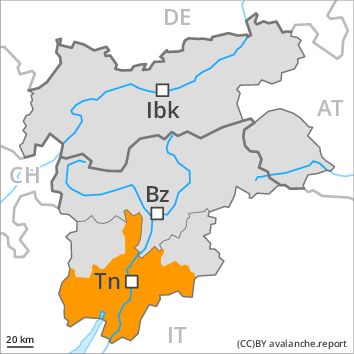
Regions
Western Verwall Mountains, Eastern Verwall Mountains, Allgäu Alps, Silvretta, Samnaun Mountains, Eastern Lechtal Alps - Ammergau Alps, Mieming Mountains, Karwendel Mountains, Brandenberg Alps, Western Kitzbühel Alps, Wilder Kaiser Mountains - Waidring Alps, Eastern Kitzbühel Alps, Western Lechtal Alps, Central Lechtal Alps, Grieskogel Mountains
Danger level
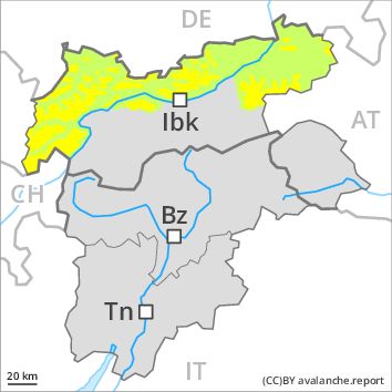
Danger Level 2 - Moderate above 2200m
Danger Level 1 - Low above 2200m
Avalanche Problem
Wind-drifted snow above 2200m, N-NE-NW
Gliding snow above 2600m, N-NE-E-SE-S-SW-W-NW
Fresh wind slabs above approximately 2200 m. Snow slides in particular on steep grassy slopes.
The fresh wind slabs represent the main danger. These can be released in particular on northwest to north to northeast facing aspects above approximately 2200 m, especially adjacent to ridgelines. They are mostly small.
Slides can occur on steep grassy slopes.
Snowpack
dp 6: cold, loose snow and wind
dp 2: gliding snow
As a consequence of a strong to storm force southerly wind, rather small wind slabs formed in the last few days at elevated altitudes. In some places wind slabs are lying on soft layers, in particular above approximately 2200 m. At low and intermediate altitudes hardly any snow is lying.
Tendency
Further decrease in avalanche danger.