Regions
Western Tuxer Alps, Glockturm Range, Grieskogel Mountains, Weißkugel Range, Gurgler Range, Central Stubai Alps, Northern Oetz and Stubai Alps
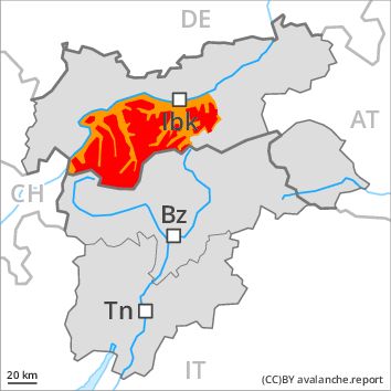
Danger level
Danger Level 4 - High above 2400m
Danger Level 3 - Considerable above 2400m
Avalanche Problem
Wind-drifted snow above 2400m, N-NE-E-SE-S-SW-W-NW
Gliding snow above the treeline, E-SE-S-SW-W

Fresh wind slabs represent the main danger. Gliding avalanches and wet snow slides are to be expected however even now.
Further increase in avalanche danger as a consequence of fresh snow and wind. The fresh and somewhat older wind slabs represent the main danger. The avalanche prone locations for dry avalanches are to be found in particular adjacent to ridgelines and on steep slopes above approximately 2400 m. In many cases the dry avalanches are medium-sized and easily released.
As the penetration by moisture increases more small to medium-sized gliding avalanches and moist snow slides are possible. This applies in particular on steep grassy slopes as well as at low and intermediate altitudes.
Snowpack
dp 6: cold, loose snow and wind
dp 2: gliding snow
Over a wide area 30 to 50 cm of snow, and even more in some localities, will fall above approximately 800 m. The somewhat older wind slabs of the last few days must be evaluated with care and prudence in all aspects above approximately 2400 m. The snowpack will be subject to considerable local variations at high altitudes and in high Alpine regions. At low and intermediate altitudes the snow is moist.
Tendency
Hardly any decrease in avalanche danger as the precipitation eases.
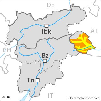
Regions
Western Lechtal Alps, Central Lechtal Alps, Western Verwall Mountains, Eastern Verwall Mountains, Allgäu Alps, Silvretta, Samnaun Mountains, Eastern Lechtal Alps - Ammergau Alps, Mieming Mountains
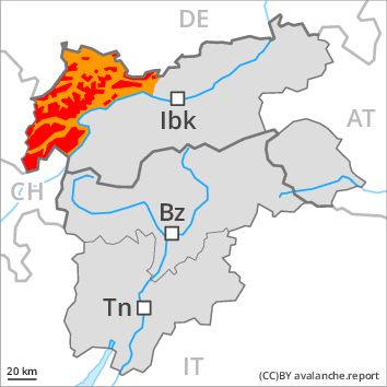
Danger level
Danger Level 4 - High above the treeline
Danger Level 3 - Considerable above the treeline
Avalanche Problem
Wind-drifted snow above the treeline, N-NE-E-SE-S-SW-W-NW
Gliding snow above the treeline, N-NE-E-SE-S-SW-W-NW
Fresh wind slabs represent the main danger. Gliding avalanches and wet snow slides are to be expected however even now.
Further increase in avalanche danger as a consequence of fresh snow and stormy weather. The fresh and somewhat older wind slabs represent the main danger. The avalanche prone locations for dry avalanches are to be found in particular adjacent to ridgelines above approximately 1800 m. In some cases the avalanches are large and very easily released.
As the moisture increases medium-sized and, in isolated cases, large gliding avalanches and moist snow slides are possible. This applies in particular on steep grassy slopes and at low and intermediate altitudes.
Snowpack
dp 6: cold, loose snow and wind
dp 2: gliding snow
Over a wide area 50 to 70 cm of snow, and even more in some localities, will fall above approximately 800 m. The fresh wind slabs will become increasingly prone to triggering in particular on steep shady slopes above approximately 1800 m. The snowpack will be subject to considerable local variations at high altitudes and in high Alpine regions. At low and intermediate altitudes the snow is moist.
Tendency
Hardly any decrease in avalanche danger as a consequence of the ceasing of precipitation.
Regions
Northern Zillertal Alps, Venediger Range, Southern Zillertal Alps and High Tauern
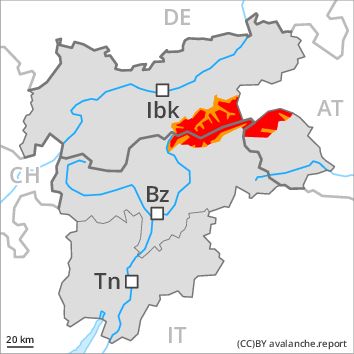
Danger level
Danger Level 4 - High above 2400m
Danger Level 3 - Considerable above 2400m
Avalanche Problem
Wind-drifted snow above the treeline, N-NE-E-SE-S-SW-W-NW
Gliding snow above the treeline, N-NE-E-SE-S-SW-W-NW
Further increase in avalanche danger as a consequence of fresh snow and wind. Gliding avalanches and wet snow slides are to be expected even now.
Fresh and somewhat older wind slabs are mostly dangerously large and prone to triggering. Caution is to be exercised in particular adjacent to ridgelines, and elsewhere on steep slopes especially at high altitudes and in high Alpine regions. Dry avalanches can additionally be released in near-surface layers, even by a single winter sport participant.
As the penetration by moisture increases small to medium-sized gliding avalanches and moist snow slides are possible. This applies in particular on steep grassy slopes at low and intermediate altitudes.
Snowpack
dp 6: cold, loose snow and wind
dp 2: gliding snow
Over a wide area 50 to 70 cm of snow, and even more in some localities, will fall above approximately 1000 m. The fresh and older wind slabs are poorly bonded with the old snowpack in all aspects above approximately 1800 m. The snowpack will be subject to considerable local variations at high altitudes and in high Alpine regions.
At low and intermediate altitudes the snow is moist.
Tendency
Hardly any decrease in danger of dry and moist avalanches as the snowfall eases.
Regions
Karwendel Mountains, Eastern Tuxer Alps, Brandenberg Alps, Western Kitzbühel Alps, Wilder Kaiser Mountains - Waidring Alps, Eastern Kitzbühel Alps
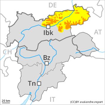
Danger level
Danger Level 3 - Considerable above the treeline
Danger Level 2 - Moderate above the treeline
Avalanche Problem
Wind-drifted snow above the treeline, N-NE-E-SE-S-SW-W-NW
Gliding snow above the treeline, N-NE-E-SE-S-SW-W-NW
Fresh wind slabs represent the main danger. Gliding avalanches and moist snow slides are to be expected however even now.
The fresh and somewhat older wind slabs represent the main danger. The avalanche prone locations are to be found on steep slopes above approximately 1800 m. Caution is to be exercised in particular adjacent to ridgelines as well as on steep slopes. Such avalanche prone locations are widespread and are difficult to recognise.
Snowpack
dp 6: cold, loose snow and wind
dp 2: gliding snow
Over a wide area 30 to 50 cm of snow, and even more in some localities, will fall above approximately 800 m. As a consequence of fresh snow and a strong to storm force northwesterly wind, avalanche prone wind slabs will form in particular adjacent to ridgelines as well as above the tree line. The snowpack will be moist at low and intermediate altitudes.
Tendency
Hardly any decrease in avalanche danger as a consequence of the ceasing of precipitation.
Regions
Glockner Range, Eastern Deferegger Alps, Schober Mountains, Lienzer Dolomites, Eastern Rieserferner Mountains
Danger level
Danger Level 3 - Considerable above the treeline
Danger Level 2 - Moderate above the treeline
Avalanche Problem
Wind-drifted snow above the treeline, N-NE-E-SE-S-SW-W-NW
Gliding snow above 2400m, N-NE-E-SE-S-SW-W-NW
The wind slabs represent the main danger.
The current avalanche situation calls for experience in the assessment of avalanche danger and careful route selection. Great caution and restraint are advisable. The more recent wind slabs are extensive and can be released easily. A few natural avalanches are to be expected, in particular on wind-loaded slopes. Especially below approximately 2400 m small and medium-sized gliding avalanches are possible.
Snowpack
dp 6: cold, loose snow and wind
dp 2: gliding snow
Some snow will fall in particular in the north and in the west. 10 to 20 cm of snow, and even more in some localities, will fall. As a consequence of the strong to storm force northwesterly wind the prevalence and size of the avalanche prone locations will increase on Tuesday. The wind slabs are to be found in particular adjacent to ridgelines and in gullies and bowls in all aspects as well as at high altitudes and in the high Alpine regions. The wind slabs have bonded poorly with the old snowpack. Faceted weak layers exist in the old snowpack in particular adjacent to ridgelines. The old snowpack will be moist below approximately 2200 m.
Tendency
Further increase in avalanche danger as a consequence of fresh snow and strong wind. This applies in particular in the regions exposed to heavier precipitation in the regions neighbouring those that are subject to danger level 4 (high). The northwesterly wind will transport the fresh and old snow. Wind slabs represent the main danger. There is a danger of gliding avalanches, in particular in the regions with a lot of snow in particular below approximately 2200 m.