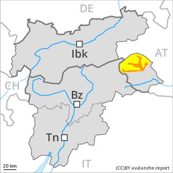
Regions
Karwendel Mountains, Western Lechtal Alps, Central Lechtal Alps, Grieskogel Mountains, Western Verwall Mountains, Eastern Verwall Mountains, Allgäu Alps, Eastern Lechtal Alps - Ammergau Alps, Mieming Mountains
Danger level
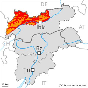
Danger Level 3 - Considerable above 2200m
Danger Level 4 - High above 2200m
Avalanche Problem
Wet snow above 2200m, N-NE-E-SE-S-SW-W-NW
Wind-drifted snow above 2200m, N-NE-E-SE-NW

Wet and gliding snow are to be critically assessed. Fresh snow requires caution.
As a consequence of the rain, the likelihood of wet and gliding avalanches being released will increase significantly below approximately 2200 m. Numerous natural avalanches are to be expected. This applies in particular in case of releases originating from starting zones that have retained the snow thus far. In some places avalanches can also penetrate deep layers and reach large size in shady places that are protected from the wind.
In addition the fresh wind slabs especially in places that are protected from the wind are easily triggered. Caution is to be exercised above approximately 2200 m. The avalanche prone locations are numerous and are barely recognisable because of the poor visibility.
Snowpack
dp 3: rain
dp 6: cold, loose snow and wind
Over a wide area intensive rain below approximately 2200 m, especially in the Allgäu Alps, in the Lechtal Alps and in the Karwendel Mountains.
Over a wide area 10 to 30 cm of snow, and even more in some localities, will fall above approximately 2200 m. The wind will be storm force over a wide area. In particular adjacent to ridgelines and in gullies and bowls avalanche prone wind slabs will form. This applies in particular on steep northwest, north and east facing slopes as well as in places that are protected from the wind.
Faceted weak layers exist in the snowpack in particular on steep west, north and east facing slopes. This applies in particular in places that are protected from the wind between approximately 2000 and 2600 m.
Tendency
The avalanche danger will persist.
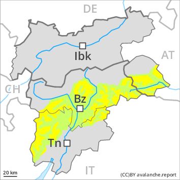
Regions
Glockturm Range, Weißkugel Range, Val Müstair Alps, Gurgler Range, Langtaufers, Central Stubai Alps, Northern Zillertal Alps, Silvretta, Samnaun Mountains, Northern Oetz and Stubai Alps
Danger level
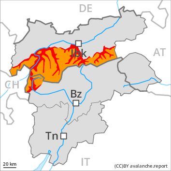
Danger Level 3 - Considerable above 2300m
Danger Level 4 - High above 2300m
Avalanche Problem
Wet snow above 2300m, N-NE-E-SE-S-SW-W-NW
Wind-drifted snow above 2300m, N-NE-E-SE-NW
Wet and gliding snow are to be critically assessed. Fresh wind slabs require caution.
As a consequence of the rain, the likelihood of wet and gliding avalanches being released will increase significantly below approximately 2300 m. Numerous natural avalanches are to be expected. This applies in particular in case of releases originating from starting zones that have retained the snow thus far. In some places avalanches can also penetrate deep layers and reach large size in shady places that are protected from the wind.
In addition the fresh wind slabs especially in places that are protected from the wind are easily triggered. Caution is to be exercised above approximately 2300 m. The avalanche prone locations are numerous and are barely recognisable because of the poor visibility.
Snowpack
dp 3: rain
dp 6: cold, loose snow and wind
Over a wide area heavy rain below approximately 2300 m.
Over a wide area 10 to 30 cm of snow. will fall above approximately 2300 m. The wind will be storm force over a wide area. Avalanche prone wind slabs will form. This applies in particular on steep northwest, north and east facing slopes as well as in places that are protected from the wind.
Faceted weak layers exist in the snowpack in particular on steep west, north and east facing slopes. This applies in particular in places that are protected from the wind between approximately 2000 and 2600 m.
Tendency
The avalanche danger will persist.
Regions
Texel Mountains, Western Pfunderer Mountains, Eastern Pfunderer Mountains, Durreck Range, Western Rieserferner Mountains, Ortler Range, Schnals Ridge, Southern Stubai Alps, Southern Zillertal Alps and High Tauern, Saldurn-Mastaun Ridge
Danger level
Danger Level 3 - Considerable
Avalanche Problem
Wind-drifted snow above the treeline, N-NE-E-SE-S-SW-W-NW
Wet snow above 2600m, N-NE-E-SE-S-SW-W-NW
Wind slabs at high altitudes and in high Alpine regions. Wet avalanches require caution.
The avalanche conditions are unfavourable. Fresh snow and wind slabs can in some places be released, even by a single winter sport participant and reach medium size. The avalanche prone locations are quite prevalent and are barely recognisable because of the poor visibility. Whumpfing sounds and the formation of shooting cracks when stepping on the snowpack can indicate the danger.
In the last three days the weather has been very mild. On Monday the likelihood of moist small and medium sized avalanches being released will increase significantly. In particular, however, an appreciable danger of wet and gliding avalanches exists. In these regions the wet avalanches can release the weakly bonded old snow as well and reach a dangerous size.
Snowpack
dp 3: rain
As a consequence of fresh snow and strong wind the wind slabs will increase in size once again as the day progresses. This applies above approximately 2400 m. The fresh snow and wind slabs will be deposited on soft layers on shady slopes. In some places relatively hard layers of snow are lying on old snow containing large grains. As a consequence of the rain, the likelihood of wet avalanches being released will increase further below approximately 2400 m.
Tendency
Tuesday: Individual natural avalanches are possible.
Regions
Western Tuxer Alps, Eastern Tuxer Alps, Brandenberg Alps, Western Kitzbühel Alps, Wilder Kaiser Mountains - Waidring Alps, Eastern Kitzbühel Alps
Danger level
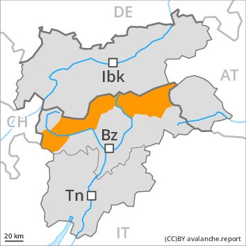
Danger Level 3 - Considerable above 2300m
Danger Level 3 - Considerable above 2300m
Avalanche Problem
Wet snow above 2300m, N-NE-E-SE-S-SW-W-NW
Wind-drifted snow above 2300m, N-NE-E-SE-NW
Wet and gliding snow are to be critically assessed. Fresh wind slabs require caution.
As a consequence of the rain, the likelihood of wet and gliding avalanches being released will increase significantly. Numerous natural avalanches are to be expected. This applies in particular in case of releases originating from starting zones that have retained the snow thus far.
In addition the fresh wind slabs especially in places that are protected from the wind are easily triggered. Caution is to be exercised above approximately 2300 m. The avalanche prone locations are numerous and are barely recognisable because of the poor visibility.
Snowpack
dp 3: rain
dp 6: cold, loose snow and wind
Over a wide area heavy rain below approximately 2300 m.
In particular in the Wilder Kaiser Mountains - Waidring Alps and in the Brandenberg Alps 10 to 30 cm of snow. will fall above approximately 2300 m. The wind will be storm force over a wide area. Avalanche prone wind slabs will form. This applies in particular on steep northwest, north and east facing slopes as well as in places that are protected from the wind.
Tendency
The avalanche danger will persist.
Regions
Glockner Range, Venediger Range, Eastern Rieserferner Mountains
Danger level
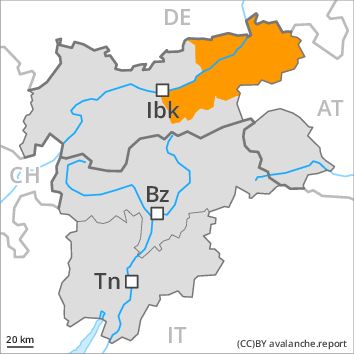
Danger Level 2 - Moderate above 2600m
Danger Level 3 - Considerable above 2600m
Avalanche Problem
Wet snow above 2600m, N-NE-E-SE-S-SW-W-NW
Wind-drifted snow above 2600m, N-NE-E-SE-NW
Wet and gliding snow are to be assessed with care and prudence. Fresh wind slabs require caution.
As a consequence of the rain, the likelihood of wet and gliding avalanches being released will increase significantly below approximately 2600 m. Natural avalanches are to be expected. This applies in particular in case of releases originating from starting zones that have retained the snow thus far. In some places avalanches can also penetrate deep layers and reach medium size in shady places that are protected from the wind.
In addition the fresh wind slabs especially in places that are protected from the wind are easily triggered. Caution is to be exercised above approximately 2600 m. The avalanche prone locations are numerous and are barely recognisable because of the poor visibility.
Snowpack
dp 3: rain
dp 6: cold, loose snow and wind
Over a wide area heavy rain below approximately 2600 m.
Over a wide area 10 to 30 cm of snow. will fall above approximately 2600 m. The wind will be storm force over a wide area. Avalanche prone wind slabs will form. This applies in particular on steep northwest, north and east facing slopes as well as in places that are protected from the wind.
Faceted weak layers exist in the snowpack in particular on steep west, north and east facing slopes. This applies in particular in places that are protected from the wind between approximately 2200 and 2600 m.
Tendency
The avalanche danger will persist.
Regions
Sexten Dolomites, Latemar, Western Deferegger Alps, Ulten Valley, Eastern Nonsberger Alps, Northern Dolomites of Fiemme, Gröden Dolomites, Southern Adamello, Eastern Deferegger Alps, Prags Dolomites, Sarntal Alps, Adamello - Presanella, Schober Mountains, Northern Brenta - Peller, Lienzer Dolomites, Western Nonsberg Alps, Southern Brenta, Fassa Valley, Sole, Pejo and Rabbi, Maddalene
Danger level
Danger Level 2 - Moderate above the treeline
Danger Level 1 - Low above the treeline
Avalanche Problem
Wind-drifted snow above the treeline, N-NE-E-SE-NW
Wet snow above 2600m, SE-S-SW-W
The danger of dry and wet avalanches will increase a little during the day.
The more recent wind slabs can still be released in particular on steep shady slopes above the tree line. As a consequence of warming during the day small and, in isolated cases, medium-sized moist and wet avalanches are possible. They can be released in the weakly bonded old snow in particular in areas where the snow cover is rather shallow. In particular transitions from a shallow to a deep snowpack where weaknesses exist in the old snowpack are precarious.
Snowpack
The storm force wind will transport the loosely bonded old snow. In particular above the tree line mostly small wind slabs will form. Restraint should be exercised because avalanches can sweep people along and give rise to falls. Large-grained weak layers exist in the snowpack especially on steep, rather lightly snow-covered shady slopes. At high altitudes and in high Alpine regions the avalanche prone locations are more prevalent.
Tendency
The wind will be strong over a wide area. The weather will be cold.
Regions
Primiero - Pale di S. Martino, Prealps, Cembra Valley, Bondone and Stivo, Vallarsa, Folgaria - Laverone, Southern Lagorai, Ledro Valley, Northern Lagorai, Paganella, Marzola - Valsugana, Pine' - Mocheni Valley
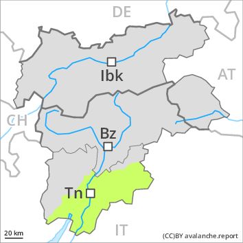
Danger level
Danger Level 1 - Low
Avalanche Problem
Wet snow above 2000m, SE-S-SW-W
Wind-drifted snow above the treeline, N-NE-E-SE-S-NW
As a consequence of warming during the day the avalanche prone locations will become more prevalent as the day progresses.
Fresh and somewhat older wind slabs are mostly rather small and can be released by large loads in particular. At high altitudes and in high Alpine regions avalanche prone locations are a little more prevalent. A clear night will be followed in the early morning by quite favourable conditions generally, but the danger of wet and gliding avalanches will increase later. In steep terrain there is a danger of falling on the hard crust.
Snowpack
The snowpack will be in most cases well bonded. The strong wind will transport only a little snow. Adjacent to ridgelines and in gullies and bowls mostly small wind slabs will form. Faceted weak layers exist in the old snowpack in particular on rather lightly snow-covered shady slopes.
Tendency
The wind will be moderate to strong at times in some localities.