Regions
Weißkugel Range, Western Verwall Mountains, Gurgler Range, Eastern Verwall Mountains, Northern Zillertal Alps, Allgäu Alps, Silvretta, Venediger Range, Samnaun Mountains, Eastern Lechtal Alps - Ammergau Alps, Karwendel Mountains, Western Lechtal Alps, Central Lechtal Alps, Glockturm Range
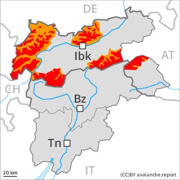
Danger level
Danger Level 4 - High above the treeline
Danger Level 3 - Considerable above the treeline
Avalanche Problem
Wind-drifted snow above the treeline, N-NE-E-SE-S-SW-W-NW

The conditions are critical. Fresh and older wind slabs represent the main danger.
As a consequence of the snowfall, the likelihood of dry avalanches being released will increase further especially above the tree line. Especially in places where the wind is storm force the avalanche danger is greater. The number and size of avalanche prone locations will increase as the day progresses. The avalanche prone locations are to be found on steep slopes of all aspects. They will increase with altitude. The brittle wind slabs will be covered with fresh snow in some cases and therefore difficult to recognise. Even single winter sport participants can release avalanches very easily, including dangerously large ones. Natural avalanches are possible, in particular on wind-loaded slopes.
In addition still more individual gliding avalanches are possible. This applies in particular in starting zones below the tree line that have retained the snow thus far.
Snowpack
dp 6: cold, loose snow and wind
dp 9: graupel blanketed with snow
Over a wide area stormy weather and fresh snow. Over a wide area persistent snowfall to low altitudes. 20 to 50 cm of snow, and even more in some localities, will fall. The storm force wind will transport the fresh snow significantly. Since Tuesday brittle wind slabs will form in particular above the tree line. These will be deposited on soft layers.
Tendency
With the end of the snowfall, the natural avalanche activity will gradually decrease. The backcountry and freeriding conditions remain critical.
Regions
Durreck Range, Val Müstair Alps, Western Rieserferner Mountains, Langtaufers, Schnals Ridge, Ortler Range, Central Stubai Alps, Southern Stubai Alps, Southern Zillertal Alps and High Tauern, Saldurn-Mastaun Ridge, Northern Oetz and Stubai Alps, Mieming Mountains, Eastern Rieserferner Mountains, Texel Mountains, Western Tuxer Alps, Glockner Range, Eastern Tuxer Alps, Brandenberg Alps, Western Kitzbühel Alps, Wilder Kaiser Mountains - Waidring Alps, Eastern Kitzbühel Alps, Grieskogel Mountains
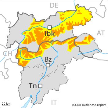
Danger level
Danger Level 3 - Considerable above the treeline
Danger Level 2 - Moderate above the treeline
Avalanche Problem
Wind-drifted snow above the treeline, N-NE-E-SE-S-SW-W-NW
Fresh and older wind slabs represent the main danger.
As a consequence of the snowfall, the likelihood of dry avalanches being released will increase further especially above the tree line. Especially in places where the wind is storm force the avalanche danger is greater. The number and size of avalanche prone locations will increase as the day progresses. The avalanche prone locations are to be found in particular on wind-loaded slopes of all aspects. They will increase with altitude. The brittle wind slabs will be covered with fresh snow in some cases and therefore difficult to recognise. Even single winter sport participants can release avalanches as before, including dangerously large ones. Natural avalanches are possible, in particular on wind-loaded slopes.
In addition still more individual gliding avalanches are possible. This applies in particular in starting zones below the tree line that have retained the snow thus far.
Snowpack
dp 6: cold, loose snow and wind
dp 2: gliding snow
Over a wide area stormy weather and fresh snow. Over a wide area persistent snowfall to low altitudes. 15 to 30 cm of snow, and even more in some localities, will fall. The storm force wind will transport the fresh snow significantly. Since Tuesday brittle wind slabs will form in particular above the tree line. These will be deposited on soft layers.
Tendency
With the end of the snowfall, the natural avalanche activity will gradually decrease. The backcountry and freeriding conditions remain critical.
Regions
Sexten Dolomites, Eastern Pfunderer Mountains, Latemar, Western Deferegger Alps, Ulten Valley, Eastern Nonsberger Alps, Northern Dolomites of Fiemme, Gröden Dolomites, Southern Adamello, Prags Dolomites, Sarntal Alps, Adamello - Presanella, Eastern Deferegger Alps, Western Pfunderer Mountains, Northern Brenta - Peller, Schober Mountains, Lienzer Dolomites, Western Nonsberg Alps, Southern Brenta, Fassa Valley, Sole, Pejo and Rabbi, Maddalene
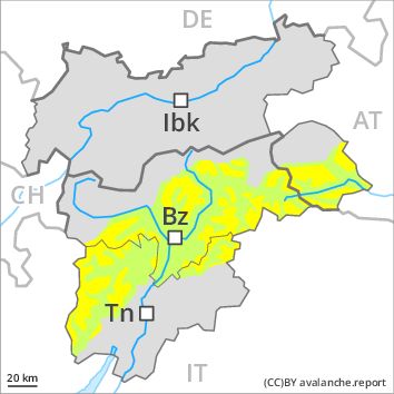
Danger level
Danger Level 2 - Moderate above the treeline
Danger Level 1 - Low above the treeline
Avalanche Problem
Wind-drifted snow above the treeline, N-NE-E-SE-S-SW-W-NW
Fresh wind slabs above the tree line.
As a consequence of the snowfall, the likelihood of dry avalanches being released will increase further especially above the tree line. Especially in places where the wind is storm force the avalanche danger is greater. The number and size of avalanche prone locations will increase as the day progresses. The avalanche prone locations are to be found in particular adjacent to ridgelines and in gullies and bowls in all aspects. They will increase with altitude. In the regions neighbouring those that are subject to danger level 3 (considerable) the avalanche danger is higher.
Snowpack
dp 6: cold, loose snow and wind
Up to 10 cm of snow, and even more in some localities, will fall. This applies in particular in the regions neighbouring those that are subject to danger level 3 (considerable). The sometimes storm force wind will transport the fresh snow significantly. In particular adjacent to ridgelines and in gullies and bowls brittle wind slabs will form. This applies in particular above the tree line.
Tendency
The danger of slab avalanches will persist.
Regions
Primiero - Pale di S. Martino, Prealps, Cembra Valley, Bondone and Stivo, Vallarsa, Folgaria - Laverone, Southern Lagorai, Ledro Valley, Northern Lagorai, Paganella, Marzola - Valsugana, Pine' - Mocheni Valley
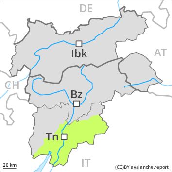
Danger level
Danger Level 1 - Low
Avalanche Problem
Wind-drifted snow above 2000m, N-NE-E-SE-S-SW-W-NW
Persistent weak layer above the treeline, N-NE-E-SE-S-NW
The sometimes strong wind will transport only a little snow.
Fresh and somewhat older wind slabs are mostly rather small and can be released by large loads in particular. At high altitudes and in high Alpine regions avalanche prone locations are a little more prevalent. The early morning will see favourable conditions generally. In steep terrain there is a danger of falling on the icy crust.
Snowpack
The snowpack will be in most cases well bonded. The sometimes storm force wind will transport the snow. Adjacent to ridgelines and in gullies and bowls mostly small wind slabs will form. Avalanche prone weak layers exist in the old snowpack in particular on very steep grassy slopes.
Tendency
The wind will be moderate to strong at times in some localities.