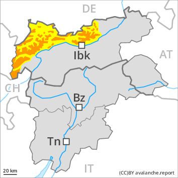
Regions
Karwendel Mountains, Western Lechtal Alps, Central Lechtal Alps, Western Verwall Mountains, Eastern Verwall Mountains, Silvretta, Allgäu Alps, Eastern Lechtal Alps - Ammergau Alps, Mieming Mountains
AM

Danger level
Danger Level 3 - Considerable above 2300m
Danger Level 2 - Moderate above 2300m
Avalanche Problem
Wind-drifted snow above 2300m, N-NE-E-SE-NW
Gliding snow above 2300m, N-NE-E-SE-S-SW-W-NW
PM
Danger level
Danger Level 3 - Considerable above 2300m
Danger Level 2 - Moderate above 2300m
Avalanche Problem
Wet snow, E-SE-S-SW-W
Gliding snow above 2300m, N-NE-E-SE-S-SW-W-NW
Increase in danger of moist avalanches as a consequence of warming during the day and solar radiation. The avalanche conditions in the morning below approximately 2300 m are generally favourable.
Numerous moist avalanches have been released as a consequence of the precipitation. In all regions there will be an appreciable decrease in the avalanche danger during the course of the night.
Late morning: Fresh and older wind slabs represent the main danger. These can be released by a single winter sport participant in particular on northwest to north to southeast facing aspects at high altitudes and in high Alpine regions. The prevalence of avalanche prone locations and likelihood of triggering will increase with altitude. In addition a moderate (level 2) danger of gliding avalanches exists, especially below approximately 2300 m on steep grassy slopes.
Midday and afternoon: As the day progresses as a consequence of warming during the day and solar radiation there will be a rapid increase in the danger of moist and wet avalanches. More frequent small and medium-sized moist loose snow avalanches are to be expected. This applies on extremely steep sunny slopes. More frequent small and medium-sized gliding avalanches are to be expected. This applies on steep grassy slopes in all aspects below approximately 2300 m. This also applies on steep sunny slopes below approximately 2600 m. As the day progresses the likelihood of slab avalanches being released will increase a little at high altitudes and in high Alpine regions.
Snowpack
dp 10: springtime scenario
dp 6: cold, loose snow and wind
Outgoing longwave radiation during the night will be good over a wide area. The surface of the snowpack will freeze to form a strong crust only at high altitudes and will soften during the day. The old snowpack will be wet all the way through at low and intermediate altitudes. In some places fresh snow and wind slabs are lying on soft layers. This applies in particular above approximately 2300 m. In very isolated cases weak layers exist in the old snowpack in particular on west, north and northeast facing slopes, especially above approximately 2500 m.
Tendency
Decrease in avalanche danger as the temperature drops.
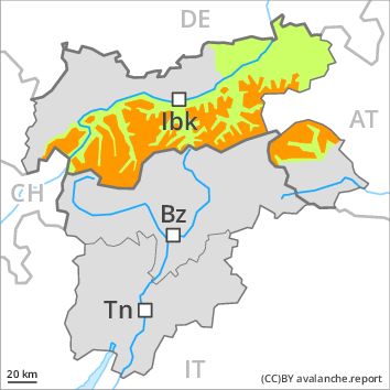
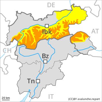
Regions
Weißkugel Range, Gurgler Range, Central Stubai Alps, Northern Zillertal Alps, Venediger Range, Samnaun Mountains, Northern Oetz and Stubai Alps, Eastern Rieserferner Mountains, Western Tuxer Alps, Glockner Range, Eastern Tuxer Alps, Brandenberg Alps, Western Kitzbühel Alps, Wilder Kaiser Mountains - Waidring Alps, Eastern Kitzbühel Alps, Glockturm Range, Grieskogel Mountains
AM
Danger level
Danger Level 3 - Considerable above 2300m
Danger Level 1 - Low above 2300m
Avalanche Problem
Wind-drifted snow above 2300m, N-NE-E-SE-NW
Gliding snow above 2300m, N-NE-E-SE-S-SW-W-NW
PM
Danger level
Danger Level 3 - Considerable above 2300m
Danger Level 2 - Moderate above 2300m
Avalanche Problem
Wet snow, E-SE-S-SW-W
Gliding snow above 2300m, N-NE-E-SE-S-SW-W-NW
Increase in danger of moist avalanches as a consequence of warming during the day and solar radiation. The avalanche conditions in the morning below approximately 2300 m are generally favourable.
Numerous moist avalanches have been released as a consequence of the precipitation. In all regions there will be an appreciable decrease in the avalanche danger during the course of the night.
Late morning: Fresh and older wind slabs represent the main danger. These can be released by a single winter sport participant in particular on northwest to north to southeast facing aspects at high altitudes and in high Alpine regions. The prevalence of avalanche prone locations and likelihood of triggering will increase with altitude. In addition a certain danger of gliding avalanches exists, especially below approximately 2300 m on steep grassy slopes.
Midday and afternoon: As the day progresses as a consequence of warming during the day and solar radiation there will be a rapid increase in the danger of moist and wet avalanches. More frequent small and medium-sized moist loose snow avalanches are to be expected. This applies on extremely steep sunny slopes. More frequent small and medium-sized gliding avalanches are to be expected. This applies on steep grassy slopes in all aspects below approximately 2300 m. This also applies on steep sunny slopes below approximately 2600 m. As the day progresses the likelihood of slab avalanches being released will increase a little at high altitudes and in high Alpine regions.
Snowpack
dp 10: springtime scenario
dp 6: cold, loose snow and wind
Outgoing longwave radiation during the night will be good over a wide area. The surface of the snowpack will freeze to form a strong crust only at high altitudes and will soften during the day. The old snowpack will be wet all the way through at low and intermediate altitudes. In some places fresh snow and wind slabs are lying on soft layers. This applies in particular above approximately 2300 m. In very isolated cases weak layers exist in the old snowpack in particular on west, north and northeast facing slopes, especially above approximately 2500 m.
Tendency
Decrease in avalanche danger as the temperature drops.
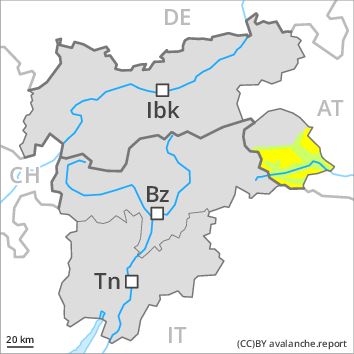
Regions
Eastern Deferegger Alps, Schober Mountains, Lienzer Dolomites
AM
Danger level
Danger Level 2 - Moderate above 2300m
Danger Level 1 - Low above 2300m
Avalanche Problem
Wind-drifted snow above 2300m, N-NE-E-SE-NW
PM
Danger level
Danger Level 2 - Moderate above 2300m
Danger Level 2 - Moderate above 2300m
Avalanche Problem
Wet snow, E-SE-S-SW-W
Gliding snow above 2300m, N-NE-E-SE-S-SW-W-NW
Increase in danger of moist avalanches as a consequence of warming during the day and solar radiation. The avalanche conditions in the morning below approximately 2300 m are generally favourable.
Early morning: Fresh and older wind slabs represent the main danger. These can be released in isolated cases, but mostly only by large additional loads, in particular on northwest to north to southeast facing aspects above approximately 2300 m. The prevalence of avalanche prone locations and likelihood of triggering will increase with altitude.
Midday and afternoon: As the day progresses as a consequence of warming during the day and solar radiation there will be a rapid increase in the danger of moist and wet avalanches. More frequent small and medium-sized moist loose snow avalanches are to be expected. This applies on extremely steep sunny slopes. More frequent small and medium-sized gliding avalanches are to be expected. This applies on steep grassy slopes in all aspects below approximately 2200 m. This also applies on steep sunny slopes below approximately 2600 m. As the day progresses the likelihood of slab avalanches being released will increase a little at high altitudes and in high Alpine regions.
Snowpack
dp 10: springtime scenario
dp 6: cold, loose snow and wind
Outgoing longwave radiation during the night will be good over a wide area. The surface of the snowpack will freeze to form a strong crust and will soften during the day. The old snowpack will be moist at low and intermediate altitudes. In some places fresh snow and wind slabs are lying on soft layers. This applies in particular above approximately 2300 m. In very isolated cases weak layers exist in the old snowpack in particular on shady slopes.
Tendency
Decrease in avalanche danger as the temperature drops.