Regions
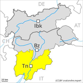
Latemar, Southern Adamello, Primiero - Pale di S. Martino, Adamello - Presanella, Prealps, Northern Brenta - Peller, Cembra Valley, Bondone and Stivo, Vallarsa, Western Nonsberg Alps, Folgaria - Laverone, Southern Brenta, Fassa Valley, Sole, Pejo and Rabbi, Southern Lagorai, Ledro Valley, Northern Lagorai, Maddalene, Paganella, Marzola - Valsugana, Pine' - Mocheni Valley
Danger level
Danger Level 2 - Moderate above the treeline
Danger Level 2 - Moderate above the treeline
Avalanche Problem
New snow above the treeline, N-NE-E-SE-S-SW-W-NW

As a consequence of fresh snow and wind a moderate avalanche danger will prevail.
The Avalanche Warning Service currently has only a small amount of information that has been collected in the field.
The fresh snow will be deposited on the unfavourable surface of an old snowpack in all aspects. The wind slabs represent the main danger. These can sometimes be released by small loads, especially on very steep slopes in all aspects in particular above the tree line. Mostly the dry avalanches are medium-sized.
Natural avalanches are to be expected, caution is to be exercised in particular at the base of rock walls and behind abrupt changes in the terrain above the tree line as well as on very steep slopes.
Snowpack
dp 6: cold, loose snow and wind
Over a wide area 20 to 30 cm of snow, and even more in some localities, will fall above approximately 1000 m. Over a wide area fresh snow is lying on a hard crust. It is bonding poorly with the old snowpack in all aspects.
Tendency
The avalanche danger will persist.
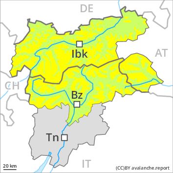
Regions
Sexten Dolomites, Allgäu Alps, Eastern Lechtal Alps - Ammergau Alps, Mieming Mountains, Karwendel Mountains, Brandenberg Alps, Wilder Kaiser Mountains - Waidring Alps, Western Lechtal Alps, Central Lechtal Alps, Grieskogel Mountains, Val Müstair Alps, Western Verwall Mountains, Langtaufers, Eastern Verwall Mountains, Schnals Ridge, Silvretta, Southern Stubai Alps, Samnaun Mountains, Southern Zillertal Alps and High Tauern, Northern Oetz and Stubai Alps, Saldurn-Mastaun Ridge, Western Tuxer Alps, Texel Mountains, Eastern Tuxer Alps, Sarntal Alps, Western Kitzbühel Alps, Western Pfunderer Mountains, Eastern Kitzbühel Alps, Glockturm Range, Eastern Pfunderer Mountains, Durreck Range, Weißkugel Range, Western Rieserferner Mountains, Gurgler Range, Western Deferegger Alps, Central Stubai Alps, Ortler Range, Northern Zillertal Alps, Ulten Valley, Venediger Range, Eastern Nonsberger Alps, Eastern Rieserferner Mountains, Northern Dolomites of Fiemme, Glockner Range, Gröden Dolomites, Eastern Deferegger Alps, Prags Dolomites, Schober Mountains, Lienzer Dolomites
Danger level
Danger Level 2 - Moderate above the treeline
Danger Level 1 - Low above the treeline
Avalanche Problem
Wind-drifted snow above the treeline, N-NE-E-SE-S-SW-W-NW
As a consequence of fresh snow and wind a moderate avalanche danger will prevail.
The Avalanche Warning Service currently has only a small amount of information that has been collected in the field.
The wind slabs represent the main danger. These can sometimes be released by small loads, especially on very steep slopes in all aspects in particular above the tree line. In some cases the dry avalanches are medium-sized.
Snowpack
dp 6: cold, loose snow and wind
Over a wide area 10 to 20 cm of snow, and even more in some localities, will fall. Over a wide area fresh snow and wind slabs are lying on a hard crust. The weather will be cold. The brittle wind slabs remain for the foreseeable future prone to triggering.
Tendency
Gradual decrease in avalanche danger as the snowfall eases.