Weak layers in the old snowpack necessitate caution.
Avalanches can in some places be released in the weakly bonded old snow, even by a single winter sport participant, in particular on steep west, north and east facing slopes between approximately 2200 and 2600 m. Caution is to be exercised at transitions from a shallow to a deep snowpack, when entering gullies and bowls for example. Avalanches can in some cases reach dangerously large size. In addition the somewhat older wind slabs are capable of being triggered in some cases still. Adjacent to ridgelines and in gullies and bowls the avalanche prone locations are more prevalent.
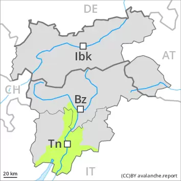
Snowpack
dp.7: snow-poor zones in snow-rich surrounding
In its middle, the snowpack is faceted and weak, especially on shady slopes between approximately 2200 and 2600 m. Snow profiles and stability tests confirm this situation. The somewhat older wind slabs are poorly bonded with the old snowpack especially on wind-protected shady slopes. They are mostly easy to recognise but prone to triggering. As a consequence of mild temperatures, solar radiation and the light to moderate wind, the snow drift accumulations stabilised during the last few days, in particular on sunny slopes.
Tendency
As a consequence of the occasionally strong northerly wind, fresh snow drift accumulations will form on Saturday. In the regions exposed to the foehn wind there will be only a slight increase in the avalanche danger.
Danger level
2400m
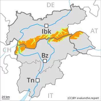
Avalanche Problem
Wind-drifted snow
2400m
Old wind slabs are to be evaluated with care and prudence.
The various wind slabs of the last few days are in some cases still prone to triggering. They can be released by a single winter sport participant especially on steep shady slopes above approximately 2400 m. Caution is to be exercised in places that are protected from the wind, as well as in gullies and bowls, and behind abrupt changes in the terrain. The wind slabs are mostly easy to recognise. Avalanches can in isolated cases be released in the old snowpack also. Such avalanche prone locations are to be found in particular on steep shady slopes above approximately 2200 m and at transitions from a shallow to a deep snowpack. In the northwest and in the north these avalanche prone locations are more prevalent. Avalanches can reach medium size.
Snowpack
dp.6: cold, loose snow and wind dp.7: snow-poor zones in snow-rich surrounding
The somewhat older wind slabs are poorly bonded with the old snowpack especially on wind-protected shady slopes. They are in some cases prone to triggering. As a consequence of mild temperatures, solar radiation and the light to moderate wind, the snow drift accumulations stabilised during the last few days, in particular on sunny slopes. Here the snowpack is better bonded. The old snowpack will be prone to triggering in some places, especially on shady slopes between approximately 2200 and 2600 m.
Tendency
As a consequence of the occasionally strong northerly wind, fresh snow drift accumulations will form on Saturday. In the regions exposed to the foehn wind there will be only a slight increase in the avalanche danger.
Danger level
2200m
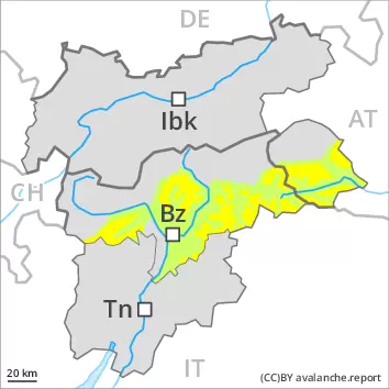
Avalanche Problem
Wind-drifted snow
2200m
The snowpack will be in most cases stable. Fresh wind slabs require caution.
As a consequence of a strong northerly wind, sometimes avalanche prone wind slabs formed in the last few days in some localities. These avalanche prone locations are to be found in all aspects at elevated altitudes and in gullies and bowls, and behind abrupt changes in the terrain. They are mostly easy to recognise and to be assessed with care and prudence. Weak layers in the old snowpack can be released especially by large additional loads. At lower altitudes and below the tree line the snowpack is well bonded.
Snowpack
At high altitudes and in high Alpine regions less snow than usual is lying. Over a wide area no snow is lying. As a consequence of mild temperatures, solar radiation and the light to moderate wind, the snow drift accumulations stabilised during the last few days, in particular on sunny slopes. Here the snowpack is better bonded. The old snowpack will be prone to triggering in some places, especially on shady slopes between approximately 2200 and 2600 m.
Tendency
As a consequence of the occasionally strong northerly wind, fresh snow drift accumulations will form on Saturday. In the regions exposed to the foehn wind there will be only a slight increase in the avalanche danger.
Danger level
2200m
Avalanche Problem
Wind-drifted snow
2200m
Persistent weak layer
2200m
Old wind slabs are to be evaluated with care and prudence.
The various wind slabs of the last few days are in some cases still prone to triggering. They can be released by a single winter sport participant especially on steep shady slopes above approximately 2400 m. Caution is to be exercised in places that are protected from the wind, as well as in gullies and bowls, and behind abrupt changes in the terrain. The wind slabs are mostly easy to recognise. Avalanches can in isolated cases be released in the old snowpack also. Such avalanche prone locations are to be found in particular on steep shady slopes above approximately 2200 m and at transitions from a shallow to a deep snowpack. Avalanches can reach medium size.
Snowpack
dp.6: cold, loose snow and wind dp.7: snow-poor zones in snow-rich surrounding
The somewhat older wind slabs are poorly bonded with the old snowpack especially on wind-protected shady slopes. They are in some cases prone to triggering. As a consequence of mild temperatures, solar radiation and the light to moderate wind, the snow drift accumulations stabilised during the last few days, in particular on sunny slopes. Here the snowpack is better bonded. The old snowpack will be prone to triggering in some places, especially on shady slopes between approximately 2200 and 2600 m.
Tendency
As a consequence of the occasionally strong northerly wind, fresh snow drift accumulations will form on Saturday. In the regions exposed to the foehn wind there will be only a slight increase in the avalanche danger.
Danger level
2200m
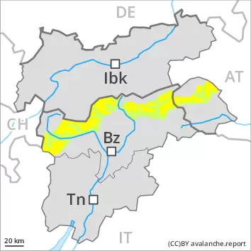
Avalanche Problem
Persistent weak layer
2600m
2200m
Wind-drifted snow
2400m
Weak layers in the old snowpack necessitate caution.
Avalanches can in some places be released in the weakly bonded old snow by large loads, in particular on steep west, north and east facing slopes between approximately 2200 and 2600 m. Caution is to be exercised at transitions from a shallow to a deep snowpack, when entering gullies and bowls for example. Avalanches can in some cases reach dangerously large size. In addition the somewhat older wind slabs are capable of being triggered in some cases still. Adjacent to ridgelines and in gullies and bowls the avalanche prone locations are more prevalent.
Snowpack
dp.7: snow-poor zones in snow-rich surrounding
Some snow will fall in some regions. In its middle, the snowpack is faceted and weak, especially on shady slopes between approximately 2200 and 2600 m. Snow profiles and stability tests confirm this situation. The somewhat older wind slabs are poorly bonded with the old snowpack especially on wind-protected shady slopes. They are mostly easy to recognise but prone to triggering. As a consequence of mild temperatures, solar radiation and the light to moderate wind, the snow drift accumulations stabilised during the last few days, in particular on sunny slopes.
Tendency
Hardly any increase in avalanche danger as a consequence of the new snow.
Danger level
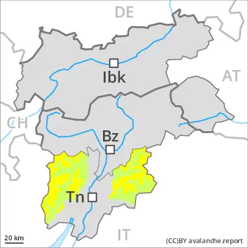
Avalanche Problem
Wind-drifted snow
The snowpack will be in most cases stable. Over a wide area only a little snow is lying.
The somewhat older wind slabs are mostly small and can only be released in isolated cases. Individual avalanche prone locations are to be found in particular on extreme shady slopes above approximately 2000 m. In the other regions the snowpack is well bonded. In steep terrain there is a danger of falling on the hard snow surface.
Snowpack
At high altitudes and in high Alpine regions less snow than usual is lying. As a consequence of mild temperatures, solar radiation and the light to moderate wind, the snow drift accumulations stabilised during the last few days. On sunny slopes and at intermediate altitudes only a little snow is lying. Below the tree line from a snow sport perspective, insufficient snow is lying.