New snow and wind slabs represent the main danger.
As a consequence of new snow and a storm force northerly wind, easily released wind slabs will form in particular above the tree line, but in isolated cases also on wind-loaded slopes below the tree line. In all aspects the wind slabs will increase in size once again as the day progresses. Mostly avalanches are medium-sized and can be released easily even by a single winter sport participant. The avalanche prone locations are to be found especially on wind-loaded slopes and in gullies and bowls, and behind abrupt changes in the terrain. They are barely recognisable because of the poor visibility. In particular on wind-loaded slopes individual natural avalanches are possible. Snow sport activities outside marked and open pistes call for experience in the assessment of avalanche danger.
Snowpack
dp.6: cold, loose snow and wind
Over a wide area 20 to 40 cm of snow, and even more in some localities, will fall on Saturday. The wind will be storm force over a wide area. The wind will transport the new snow significantly. At elevated altitudes snow depths vary greatly, depending on the infuence of the wind. The old snowpack will be subject to considerable local variations. The fresh snow and the wind slabs are lying on soft layers above the tree line, in particular in places that are protected from the wind. In very isolated cases weak layers exist in the centre of the snowpack. This applies in particular on very steep shady slopes above approximately 2400 m. At low and intermediate altitudes less snow than usual is lying.
Tendency
Wind slabs are to be evaluated critically. Loose snow avalanches are to be expected as a consequence of solar radiation, especially on extremely steep slopes.
Danger level
treeline
Avalanche Problem
Wind-drifted snow
Treeline
Fresh wind slabs represent the main danger.
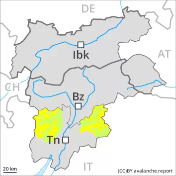
As a consequence of a storm force northerly wind, avalanche prone wind slabs will form on Saturday. The avalanche prone locations are to be found in all aspects above approximately 2000 m and in gullies and bowls, and behind abrupt changes in the terrain. Fresh wind slabs are to be avoided especially in steep terrain. In regions neighbouring those that are subject to danger level 3 (considerable) the avalanche prone locations are more prevalent and the danger is slightly greater, caution is to be exercised in the regions of the south exposed to the foehn wind, including below the tree line. Additionally in very isolated cases avalanches can also be released in the old snowpack. In some cases avalanches are medium-sized. Meticulous route selection is recommended.
Snowpack
dp.6: cold, loose snow and wind
On Saturday the wind will be storm force over a wide area. Some snow will fall in particular in the north and in the northeast. The wind will transport the fresh and old snow. The small quantity of fresh snow and the wind slabs to be found especially adjacent to riddgelines are lying on soft layers on steep shady slopes above the tree line, in particular in places that are protected from the wind. The old snowpack will be generally subject to considerable local variations. In very isolated cases weak layers exist in the centre of the snowpack. This applies in particular on very steep shady slopes above approximately 2400 m.
Tendency
Fresh wind slabs require caution. In the north and in the northeast the avalanche danger is higher.
Danger level
treeline
Avalanche Problem
Wind-drifted snow
Treeline
Fresh wind slabs represent the main danger.
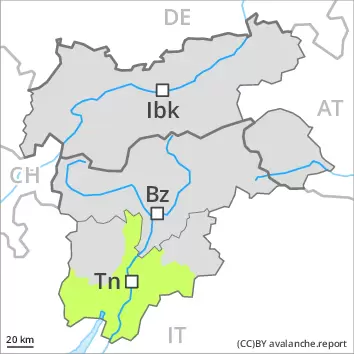
As a consequence of new snow and a storm force wind, avalanche prone wind slabs will form in particular above the tree line. The avalanche prone locations are to be found in all aspects, especially in gullies and bowls, and behind abrupt changes in the terrain. Fresh wind slabs are to be avoided especially in steep terrain. Additionally in very isolated cases avalanches can also be released in the old snowpack. In some cases avalanches are medium-sized. Meticulous route selection is recommended.
Snowpack
dp.6: cold, loose snow and wind
On Saturday the wind will be storm force over a wide area. The wind will transport the fresh and old snow. The small quantity of fresh snow and the wind slabs to be found above all adjacent to risgelines and in gullies and bowls are lying on soft layers above the tree line, in particular in places that are protected from the wind. The old snowpack will be generally subject to considerable local variations. In very isolated cases weak layers exist in the centre of the snowpack. This applies in particular on very steep shady slopes above approximately 2400 m.
Tendency
Wind slabs are to be avoided. Mostly small loose snow avalanches are to be expected as a consequence of solar radiation, especially on extremely steep slopes.
Danger level
2200m
Avalanche Problem
Wind-drifted snow
2200m
Fresh wind slabs at elevated altitudes.
The old snowpack remains generally stable. As a consequence of a sometimes strong northerly wind, mostly small wind slabs will form on Saturday. The avalanche prone locations are to be found in all aspects above approximately 2200 m and in gullies and bowls, and behind abrupt changes in the terrain. Fresh wind slabs are to be avoided especially in steep terrain. The number and size of avalanche prone locations will increase with altitude. Additionally in very isolated cases avalanches can also be released in the old snowpack. In some cases avalanches are rather small.
Snowpack
On Saturday the wind will be strong to storm force at times in some localities. The wind will transport the loosely bonded old snow, in particular above approximately 2200 m. The old snowpack will be generally subject to considerable local variations. In very isolated cases weak layers exist in the centre of the snowpack. This applies in particular on very steep shady slopes above approximately 2400 m.
Tendency
The avalanche danger will persist. Fresh wind slabs require caution. Here the danger is higher.