Wet snow slides and avalanches are still possible. Fresh wind slabs require caution.
The surface of the snowpack will cool hardly at all during the overcast night and will already be soft in the early morning. Up to 2000 m rain will fall during the night. As the day progresses as a consequence of the moist air there will be an additional increase in the danger of wet and gliding avalanches. Small to medium-sized gliding avalanches and wet snow slides are possible. This applies in all aspects below approximately 2400 m.
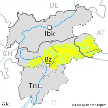
High altitudes and the high Alpine regions: The strong wind will transport the fresh and old snow. The fresh wind slabs can be released in some cases on steep shady slopes at high altitudes and in high Alpine regions. The avalanche prone locations are to be found especially adjacent to ridgelines and in gullies and bowls above approximately 2600 m. At elevated altitudes the avalanche prone locations are more prevalent.
Snowpack
dp.10: springtime scenario dp.6: cold, loose snow and wind
Over a wide area 5 to 10 cm of snow, and even more in some localities, will fall above approximately 2000 m, in particular along the border with Vorarlberg. Rain to the tree line. The wind will be strong over a wide area. Fresh wind slabs will be deposited on soft layers in particular on steep shady slopes above approximately 2600 m.
The surface of the snowpack will cool hardly at all during the overcast night and will already be soft in the early morning. This applies especially on steep sunny slopes, also in all aspects below approximately 2400 m.
Tendency
Temporary decrease in danger of wet avalanches as the temperature drops. Fresh wind slabs in high Alpine regions.
Danger level
2500m
Avalanche Problem
Wet snow
2500m
Wet snow slides and avalanches are still possible.
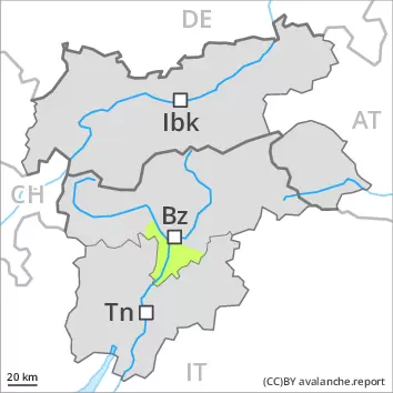
The surface of the snowpack is hardly frozen at all and will already soften in the late morning. Already in the middle of the day individual small and medium-sized wet loose snow avalanches are possible. This applies in all aspects below approximately 2500 m. As the day progresses as a consequence of the moist air there will be an additional increase in the danger. In addition a certain danger of gliding avalanches exists. This applies on steep grassy slopes in the regions with a lot of snow. Areas with glide cracks are to be avoided as far as possible.
Snowpack
dp.10: springtime scenario
As a consequence of mild temperatures and very cloudy skies the snowpack can not consolidate during the night. The surface of the snowpack will soften quickly. The high humditiy will give rise as the day progresses to a loss of strength within the snowpack below approximately 2500 m.
At elevated altitudes the situation is more favourable. The somewhat older wind slabs have bonded well with the old snowpack. The old snowpack will be generally stable. In particular on south facing slopes as well as at low and intermediate altitudes a little snow is lying.
Tendency
Temporary decrease in danger of wet avalanches as the temperature drops. Some snow will fall on Saturday in particular in the Zillertal Alps and in the Ammergau Alps.
Danger level
Avalanche Problem
Wet snow
Moist and wet snow slides are still possible.
The surface of the snowpack will freeze very little and will already be soft in the early morning. Most and wet avalanches can in some places be released easily, but they will be small in most cases. Individual avalanche prone locations are to be found in extremely steep terrain.
Snowpack
dp.10: springtime scenario
As a consequence of mild temperatures and very cloudy skies the snowpack can not consolidate during the night. The surface of the snowpack will already be soft in the early morning. In all aspects as well as in all altitude zones only a little snow is lying.
Tendency
Temporary decrease in danger of wet avalanches as the temperature drops.